Tag Archives: Services

How Wearable Smart Clothing Will Revolutionize Health, Fitness, and Fashion

Wearables are in a nascent stage since coming into vogue through the advent of Samsung Galaxy Gear in 2013 and the Apple Watch in 2015. Smartwatches and fitness devices like Fitbit continue to reign supreme and help us make our lives more efficient while tracking vital health data and improving our workouts.

The next generation of wearables will be able to cultivate even more data and transmit that information to health professionals with the help of 5G. Machine learning algorithms will help predict potential health issues based on the data gathered. In order to cultivate this data, we predict that wearable clothes fitted with sensors will rise in popularity, yielding ground-breaking applications in Fitness, Healthcare, Emergency Services, and Fashion.

FITNESS

The release of Fitbit in 2009 marked the first consumer-grade wearable focused on activity tracking, precipitating the advent of the smartwatch by four years. Since then, Fitbit has designed and released a line of products focusing on activity tracking, including the Fitbit Versa, a health and fitness smartwatch, and the Fitbit Ace, an activity tracker for children 8+.

Screen Shot 2019-02-19 at 9.08.59 AM

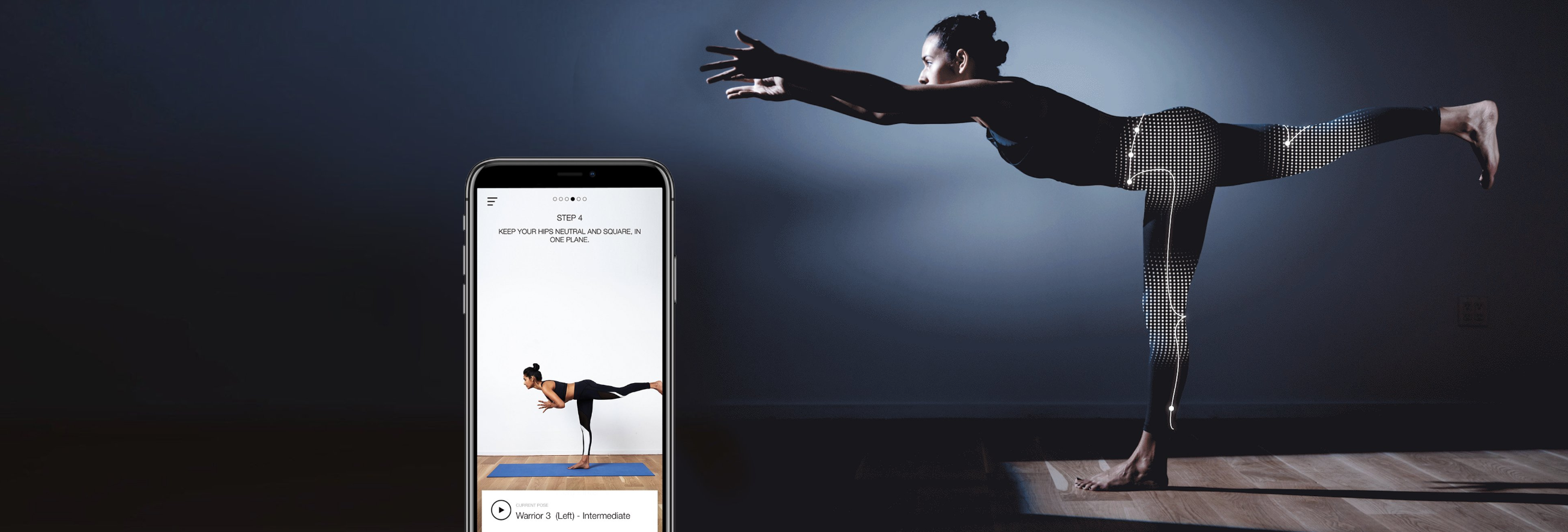
Fitbit isn’t the only major player in the wearables game. Nadi X Yoga Pants use built-in haptic vibrations to encourage wearers to move and hold positions.

Sensoria’s second generation connected socks use textile pressure sensors to track the pressure put on the user’s foot when running and inform the user when it senses too much pressure on a particular body part to prevent injury. They also track time, cadence, pace, speed, and distance.

The Thin Ice smart vest cools your body using thermo receptors, activating the bodies brown fat pathways which effectively burns white fat (bad fat).

OMsignal’s OmBra measures heart rate and breathing rhythm in addition to time, distance, cadence pace, and impact for runners.

athos

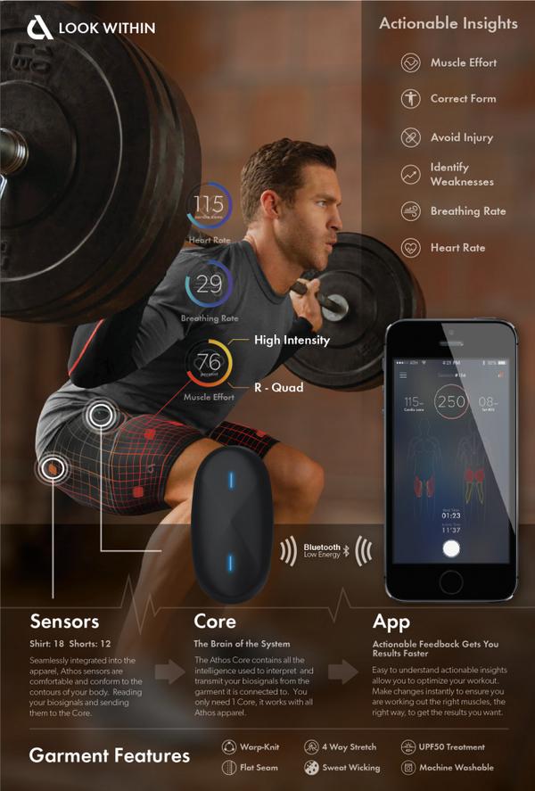
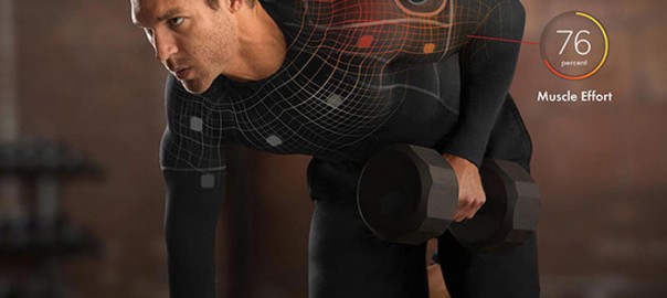
The Athos Core is perhaps the most thorough and expansive application in smart clothes today. Athos Core collects data from a line of clothing embedded with micro-EMG sensors and analyzes it to help improve your workout. Athos shirts can evaluate electrical activity produced by your muscles to track the exertion of major upper-body muscle groups (pecs, bis, tris, delts, lats, and traps).

HEALTHCARE AND EMERGENCY SERVICES

As cited in our last blog on 5G and healthcare, 86% of doctors say wearables increase patient engagement with their own health.

cleansock_phone-02

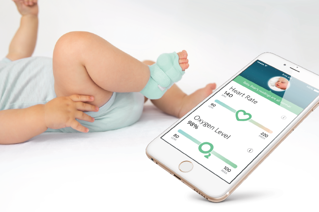
The second generation Owlet Smart Sock is a smart-sock made for babies which uses pulse oximetry technology to monitor heart rate and sleep patterns.

Siren Smartsocks are designed to prevent diabetics from suffering from foot injuries. They have microsensors designed to continuously monitor temperature for inflammation and alert users through their smartphone app.

As wearable clothes become more popular, applications will automatically contact emergency services when the wearer’s health shows major warning signs.

Invisiwear offers wearable smart jewelry and other accessories with a panic button which gives the option to share your location with loved ones and 9-1-1.

The iBeat Heart Watch monitors health and notifies your loved ones and an EMT team in emergency situations.

FASHION

“Fashion tech” is gradually earning adoption.

On a mass consumer level, Levi’s teamed up with Google’s Project Jacquard to offer a smart trucker jacket designed for urban cyclists. Conducive yarn makes it easy for the user to tap, swipe, or hold the sleeve to fulfill simple tasks like changing music tracks, block or answer calls, or access navigation information.

Vicenza-headdress-by-The-Unseen-for-Swarovski_dezeen_468_SQ5

A London-based design firm THE UNSEEN created a line of luxury accessories including a backpack, phone case, scarf, and more which respond to air pressure, body temperature, wind, sunlight, and touch to change colors.

THE FUTURE OF WEARABLE CLOTHES

Recently, NBA commissioner Adam Silver unveiled the future of the NBA Jersey: a line of smart jerseys that allow you to customize the name and number on the jersey.

There’s no doubt that the future of wearable clothes is still unveiling itself to us as 5G receives mass adoption and programmers continue to uncover potential applications of machine learning. What is clear at this point is that wearable clothes will help make the human race smarter, stronger, healthier, and more efficient.

How To Design Battery-Efficient Geolocation Apps

The ability for smartphones to offer location services fostered major opportunities for app developers looking to create new apps and enhance functionality of existing apps. Tinder, FourSquare, & Waze use geolocation in the center of their functionality to great success. In combination, these three apps can help a user determine a dinner companion, restaurant of choice, and route to the restaurant. By delivering location-sensitive information to users regardless of where they are in the country, these apps appeal to massive audiences.

Programming geolocation services into an app will have a major impact on the overall quality of the app—and it’s easier said than done. Inefficient geolocation services drain device battery life and deliver inaccurate location data. When apps drain battery life, users uninstall them. In order to determine the best method of programming geolocation services, it is vital for app developers to know who is going to be using the app and how they are going to use it.

Location can be determined by a smartphone in a number of ways. The most widespread include:

GPS: All modern iOS & Android smartphones are equipped with GPS technology. GPS can use at least four satellites to determine a user’s location within about 60 feet.

Cell ID: When GPS isn’t available, phones can use Cell ID, information from cellular towers, to determine location. Cell ID is ideal in big cities with vast amounts of cell towers. Serial fans should be familiar with how cellular tower information can be vital in identifying one’s location. GPS & Cell ID can also work in conjunction to deliver a more precise GPS location.

Wi-Fi: Devices can detect Wi-Fi networks in the same way they can detect cellular towers, but Wi-Fi is more precise as Wi-Fi networks cover smaller regions. Devices can use RSSI (Received Signal Strength Indication) to refer signals from the phone with Wi-Fi points database. Devices can also use the user’s frequently visited places, a profile or wireless fingerprint based on locations in Wi-Fi networks frequented by the user. Wi-Fi can identify a user’s position within 2 meters of accuracy.

The decision of how an app should prioritize these three methods to determine location is a vital one. If users are located in the city, that means both dense Wi-Fi router and cell tower coverage will open up options. If the app is being used primarily in a domestic situation, Wi-Fi might be both the most accurate and efficient method. Apps designed for rural areas may have to use Wi-Fi due to lack of cell towers.

Geofencing Graphic from Applidium

GEOFENCING

Geofencing utilizes a device’s GPS to determine a user’s distance from a particular point. Geofencing can sense when a user enters within a set radius defined by the coordinates of its center. Geofencing will sense when users are inside or outside of a retailer and offer action prompts for either space. There are three types of geofencing:

Static geofencing is based on a user’s position in relation to a specific place. For example, a retailer app sends a message to users who pull into the parking lot of a mall containing the retailer.

Dynamic geofencing takes into account both a user’s location and a changing data stream. For example, a parking app sends the user a message about a recently evacuated parking space that the user is approaching.

Combined geofencing determines when a user enters into a location in relation to other users. For example, apps like Yelp, Facebook, or FourSquare send notifications if a friend checks into a nearby merchant .

CREATING BATTERY-EFFICIENT APPLICATIONS

Making a geolocation app battery-efficient is one of the biggest challenges  app developers face in the programming stage. Developers must create a comprehensive strategy based on their audience.

ACTION THRESHOLDS: Defining accurate action thresholds and use-cases for an app’s geolocation services will dictate its level of battery-efficiency. The more precise your location accuracy requirements, the greater the battery drain. Action thresholds and use-cases define how an app is intended to be used, allowing a framework for developers to enact an efficient model of internal processes for location determination.

COMPREHENSIVE TESTING: Testing the app aggressively to gather a large amount of data is the only way to know the most efficient action thresholds. The more the developer understands how an app is being used, the more they can refine their programming. After release, continuing to gather analytics from user behavior and refine tactics based on how users are getting value from the app becomes a crucial ongoing process.

POLLING FREQUENCY: One of the major variables dictated by action thresholds is polling frequency. The more an app polls for locations, the better its location accuracy. The necessary level of location accuracy varies depending on the app. The precision of location accuracy necessary for an app to be functional can vary. A restaurant app, for example, might be able to get away with accuracy from 200 meters to a few kilometers, while an app that locates friends might need accuracy within 10 – 20 meters.

Evaluating the most efficient polling frequency requires thorough use-cases and some creativity. Programmers can design algorithms to reduce polling frequency if an app hasn’t changed locations for several minutes. Programmers can also analyze the speed of the device and use this data to change polling frequencies. A developer may elect to increase polling frequency as a car accelerates to ensure they maintain location accuracy within a selected radius.

DEFERRING TO OS: Many major mobile platforms will share geolocation information at an operating system level. As a result, any app that is listening can receive location updates requested by other apps. By deferring to other apps already polling for location data, apps can minimize battery drain while still retaining acceptable location data.

Check out Apple and Android’s developers’ sites for more information on best practices for programming location services.