Tag Archives: Management

The Future of Indoor GPS Part 4: Read the Room with RFID Tags

In the previous installment of our blog series on indoor positioning, we explored the future of Ultra Wideband technology. This week, we will examine RFID Tags.

The earliest applications of RFID tags date back to World War II when they were used to identify nearby planes as friends or foes. Since then, RFID technology has evolved to become one of the most cost-effective and easy to maintenance indoor positioning technologies on the market.

WHAT IS RFID?

rfid_works

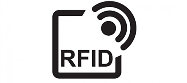
RFID refers to a wireless system with two components: tags and readers. The reader is a device with one or more antennae emitting radio waves and receiving signals back from the RFID tag.

RFID tags are attached to assets like product inventory. RFID Readers enable users to automatically track and identify inventory and assets without a direct line of sight with a read range between a few centimeters and over 20 meters. They can contain a wide range of information, from merely a serial number to several pages of data. Readers can be mobile and carried by hand, mounted or embedded into the architecture of a room.

RFID tags use radio waves to communicate with nearby readers and can be passive or active. Passive tags are powered by the reader, do not require a battery,  and have a read range of Near Contact – 25 Meters. Active tags require batteries and have an increased read range of 30 – 100+ Meters.

WHAT DOES RFID DO?

RFID is one of the most cost-effective and efficient location technologies. RFID chips are incredibly small—they can be placed underneath the skin without much discomfort to the host. For this reason, RFID tags are commonly used for pet identification.

Image via Hopeland
Image via Hopeland

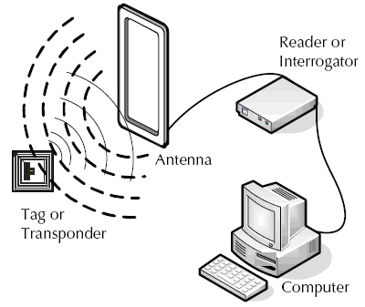
One of the most widespread uses of RFID is in inventory management. When a unique tag is placed on each product, RFID tags offer instant updates on the total number of items within a warehouse or shop. In addition, it can offer a full database of information updated in real time.

RFID has also found several use cases in indoor positioning. For example, it can identify patients and medical equipment in hospitals using several readers spaced out in the building. The readers each identify their relative position to the tag to determine its location within the building. Supermarkets similarly use RFID to track products, shopping carts, and more.

RFID has found a wide variety of use cases, including:

WHAT ARE THE CONS OF USING RFID?

Perhaps the biggest obstacle facing businesses looking to adopt RFID for inventory tracking is pricing. RFID tags are significantly more expensive than bar codes, which can store some of the same data and offer similar functionality. At about $0.09, passive RFID tags are less expensive than active RFID tags, which can run from $25-$50. The cost of active RFID tags causes many businesses to only use them for high-inventory items.

RFID tags are also vulnerable to viruses, as is any technology that creates a broadcast signal. Encrypted data can help provide an extra level of security; however, security concerns still often prevents larger enterprises from utilizing them on the most high-end merchandise.

OVERALL

RFID tags are one of the elite technologies for offering inventory management with indoor positioning. Although UWB and Bluetooth BLE beacons offer more precise and battery-efficient location services, RFID is evolving to become more energy and cost efficient.

Stay tuned for the next entry in our Indoor Positioning blog series which will explore AR applications in indoor positioning!

A Smarter World Part 3: How Smart Transportation Will Accelerate Your Business

In the last installment of our blog series on smart cities, we examined how smart infrastructure will revolutionize smart cities. This week, we will examine the many applications which will soon revolutionize smart transportation.

A smarter world means a faster, more efficient and environmentally-friendly world. And perhaps the biggest increase in efficiency and productivity will be driven by the many ways in which AI can optimize the amount of time it takes to get where you’re going.

Here are the top applications in smart transportation coming to a city near you:

Autonomous-vehicle-AdobeStock_174958313_rm

AUTONOMOUS VEHICLES

Some say autonomous vehicles are headed to market by 2020. Others say it could take decades before they are on the road. One thing is for certain, they represent a major technological advancement for smart transportation. Autonomous cars will communicate with each other to avoid accidents and contain state-of-the-art sensors to help keep you and your vehicle safe from harm.

Although autonomous vehicles are arguably the largest technological advancement on the horizon, they will also benefit greatly from a variety of smart transportation applications that will accelerate navigating your local metropolis.

Integrated-Roadways

SMART ROADS

What if we could turn roads into a true digital network, giving real-time traffic updates, supporting autonomous car technology, and providing true connectivity between vehicles and smart cities?

That’s the question tech start-up Integrated Roadways intends to answer. Integrated Roadways develops fiber-connected smart pavement outfitted with a vast amount of sensors, routers, and antennae that send information to data centers along the highway. They recently inked a 5 year deal to test out patented fiber-connected pavement in Colorado.

Smart Roads represent a major advancement in creating vehicle-to-infrastructure (V2I) connectivity. With 37,133 deaths from motor vehicles on American roads in 2017, the combination of AI applications in smart roads and autonomous cars could revolutionize vehicular transport and create a safer, faster world.

smart-traffic-lights-1_AMaJV_24429

SMART TRAFFIC LIGHTS

The vehicle-to-infrastructure connectivity spans beyond the roads and into the traffic light. Idling cars generate an estimated 30 million tons of carbon dioxide. Traffic jams can make it harder for first responders to reach emergencies. Rapid Flow proposes that the answer may be their AI-based adaptive traffic management system called Surtrac.

Surtrac uses a decentralized network of smart traffic lights equipped with cameras, radar, and other sensors to manage traffic flows. Surtrac’s sensors identify approaching vehicles, calculate their speed and trajectory, and adjust a traffic signal’s timing schedule as needed.

red line bus

SMART PUBLIC TRANSIT

There are a variety of smart applications which are revolutionizing public transportation.

In Singapore, hundreds of cameras and sensors citywide analyze traffic congestion and crowd density, enabling government officials to reroute buses at rush hour, reducing the risk of traffic jams. In Indianapolis, the electric Red Line bus service runs a 13 mile path that travels within a quarter of a mile of roughly 150,000 jobs.

One of the major disruptors which has seen rapid adoption in the smart public transport are electric scooter sharing services like Bird and Lime. Electric scooters fill in the public transportation gap for people looking to go 1-3 miles without having to walk or take a taxi. Electric scooters have seen adoption in Los Angeles, San Francisco, Salt Lake City, Brooklyn, and more cities around the globe.

CONCLUSION

Smart cities will have a host of revolutionary applications working in unison and communicating through smart infrastructure with municipalities to ensure maximum efficiency and safety when it comes to transportation. In our next installment of our series on smart cities, we’ll examine how smart security will help keep city-dwellers safe.

A Smarter World Part 2: How Smart Infrastructure Will Reshape Your City

Imagine a city that monitors its own health, identifies potential fail points using AI algorithms, and autonomously takes action to prevent future disasters.

This is the smart-city of the future. In our first installment of our blog series on Smart Cities, we ran through an overview of how Smart Cities will change our world. In this second entry of our blog on smart cities, we’ll examine perhaps the biggest building block necessary to create a smart city: smart infrastructure.

The construction of a smart city begins with developing a vast, city-wide IoT system, embedding sensors and actuators into the infrastructure of the city to create a network of smart things. The sensors and actuators collect data and send it to field gateways which preprocess and filter data before transmitting it through a cloud gateway to a Data Lake. The Data Lake stores a vast amount of data in its raw state. Gradually, data is extracted for meaningful insights and sent to the Big Data warehouse where it’s structured. From here, monitoring and basic analytics will occur to determine potential fail points and preventative measures.

Check out the breakdown below:

Breakdown

As you can see, it all begins with the construction of smart infrastructure that can collect data. Here are some of the big applications in the smart infrastructure space:

STRUCTURAL HEALTH

One of the major applications of smart infrastructure will be monitoring key data points in major structures, such as the vibrations and material conditions of buildings, bridges, historical monuments, roads, etc.

Cultivating data will initiate basic analysis and preventative measures, but as we gather more and more data, AI and machine learning algorithms will learn from vast statistical analysis and be able to analyze historical sensor data to identify trends and create predictive models to prevent future disasters from happening with unprecedented accuracy.

Learn more about how Acellant is building the future of structure health monitoring.

ENVIRONMENTAL APPLICATIONS

There are a multitude of potentially environmental applications for smart infrastructure designed to optimize city activities for environmental health. For example, embedding street lights with intelligent and weather adaptive lighting will reduce the amount of energy necessary to keep roads alight.

Air pollution monitoring will help control CO2 emissions of factories and monitor the pollution emitted by cars. Ultimately, earthquake early detection can help monitor distributed control in specific places of tremors.

2017-05-08-151015.975562trashcity

WASTE MANAGEMENT

Boston is well-known as one of the top college cities in the United States. Every fall, over 160,000 college students from MIT, Harvard, Northeastern, BU, BC, Berklee School of Music, and more move in to their new living spaces, causing undue stress on the city’s waste management administration. ANALYZE BOSTON, the city’s open data portal, provided key data points such as housing rentals, trash volume and pick-up frequency, enabling a project called TRASH CITY to reroute waste management routes during this trying time.

CONCLUSION

Projects like Trash City show the many ways in which we can optimize city operations by analyzing data effectively. As smart infrastructure enables the collection of more and more data, projects like TRASH CITY will become more efficient and more effective.

Of course, the biggest application of Smart Infrastructure will be the many ways in which it will change how you get from A to B. Next week, we’ll focus in on smart transportation and how it will reshape metropolitan transportation.